
Fixed-Wing Mission Navigation
Problem Statement
The autopilot will hold any course, altitude and airspeed you give it. A mission has to decide which — continuously, from a waypoint list, a loiter point or a pattern, and from wherever the aircraft happens to be when the mode changes under it.
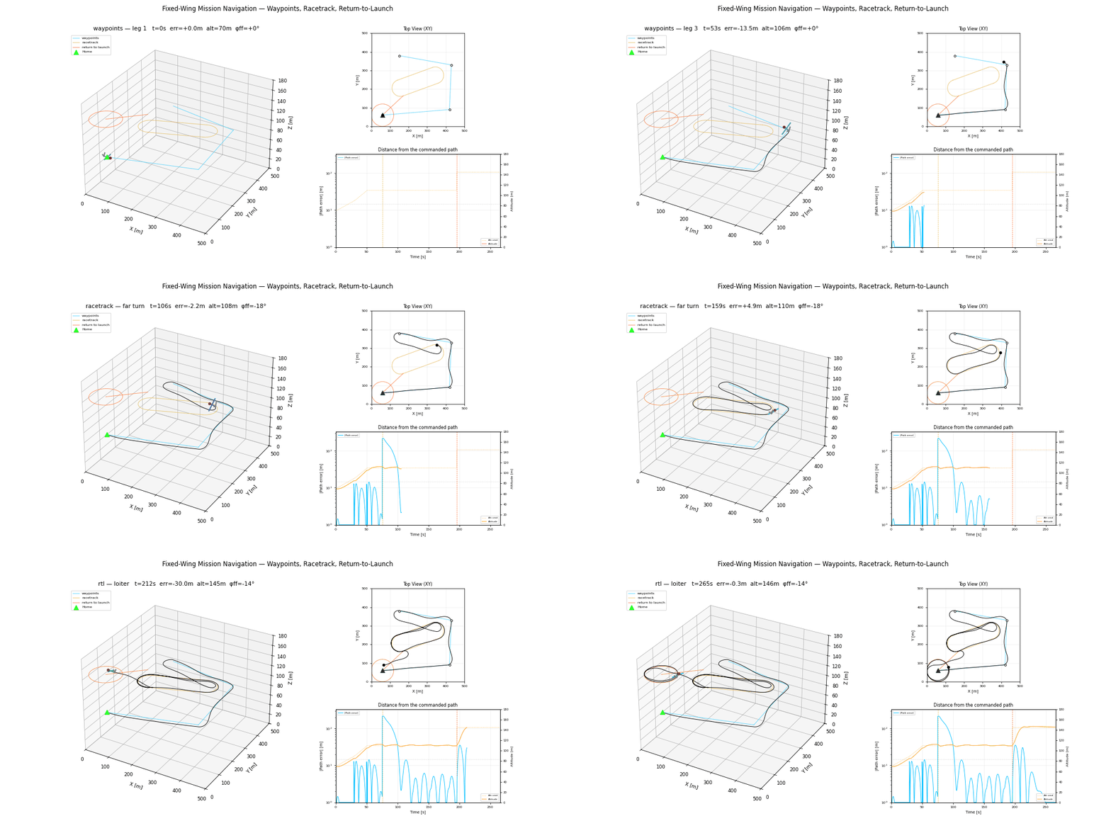
This simulation flies all three mission modes in one flight, on one airframe, through one guidance layer:
- Waypoint legs — four points and a climb.
- Racetrack — two straights joined by half-orbits, flown twice.
- Return to launch — triggered mid-pattern.
The hand-overs are the point. Each mode change happens somewhere the new plan did not anticipate, which is exactly the situation an RTL has to cope with for real.
Model and Formulation
Straight-line following (Beard & McLain eq. 10.8), with cross-track error e positive to the left of the path in this library's ENU frame:
Orbit following (eq. 10.13), with
The full derivation — including why both survive the NED→ENU conversion unchanged, and how
Why the trainer
The 0.6 kg foam trainer cruises at 12 m/s and turns in under 15 m, so the whole mission — a 900 m survey, a 200 m racetrack and a return — fits a 500 m world. The Aerosonde would need 125 m of turn radius and a world eight times the size to show the same thing.
This is the same lesson as the fixed-wing flight demo: the airframe has to match the world, or the demo is showing the world's limits rather than the algorithm's.
Algorithm Procedure
- Build a plan: a list of legs, each a geometric path plus a termination test.
- Each step, ask the active leg for a course, altitude and airspeed at the current position, and for the coordinated-turn bank its path requires.
- Advance past any leg that is finished — a straight when the aircraft is inside the acceptance radius or past the half-plane, an orbit when it has swept its commanded angle.
- Hand the result to the autopilot as an
AutopilotCommand.
The manager owns exactly one piece of state: which leg is active. Everything about where the paths are is stateless geometry.
Measured Behaviour
| Phase | Capture peak | Settled mean | Settled max |
|---|---|---|---|
| Waypoints | 12.8 m | 6.1 m | 14.3 m |
| Racetrack | 216.0 m | 3.8 m | 14.1 m |
| Return to launch | 35.4 m | 2.0 m | 6.7 m |
"Settled" is measured 30 s after each mode change. The capture peaks are the demo working, not failing: the racetrack's 216 m is simply how far from the pattern the aircraft was when the survey finished, and the guidance closes it.
The waypoint figures are the loosest of the three, and mostly by design — the acceptance radius hands over to the next leg one fillet radius before each corner, so the aircraft is genuinely off the old line while turning onto the new one.
The flight ends 59.7 m from home at 146.2 m, against a commanded 60 m holding circle at 145 m.
The error panel plots magnitude on a log axis, floored at 1 m. Each mode change throws the error two orders of magnitude above where it settles, and a linear axis wide enough to show a capture flattens everything in between onto the zero line.
Tuning Guidance
GuidanceGains.loop_separationis the one knob that matters. Below about 1.5 the guidance asks for course changes faster than the autopilot delivers and the aircraft overshoots the line; well above 2 the capture is merely slow.course_infinitysets how hard the aircraft cuts in from far away. It must stay under 90°: at exactly 90° the aircraft is told to fly perpendicular to the path, which it can never roll out of in finite lateral distance.- Pattern radii below the airframe's bank-limited turn radius are refused, not flown badly. If
racetrack_planraises, the pattern is the problem, not the gains.
Usage
flybots run fixed_wing_mission
# or
python -m flybots.simulations.path_tracking.fixed_wing_mission
Result
Reference
R. W. Beard, T. W. McLain, Small Unmanned Aircraft: Theory and Practice, Princeton University Press, 2012 — Chapters 10 and 11.
See also
- Mission navigation — the guidance layer in full
- Autopilots — the loop underneath it
- Fixed-wing flight — the autopilot alone